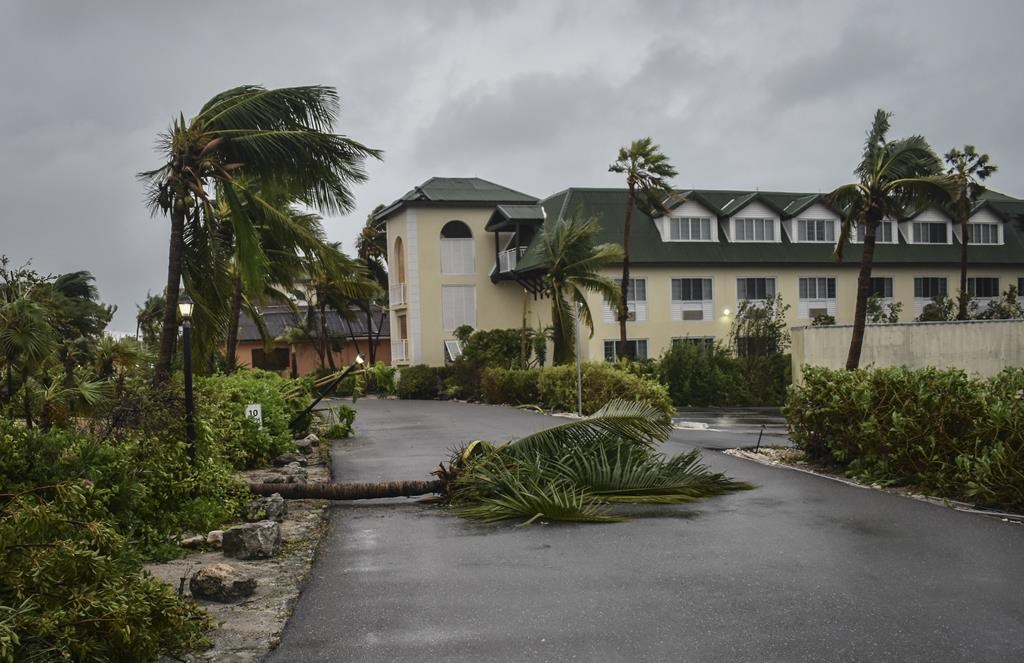
HALIFAX — Residents of Atlantic Canada and the eastern edge of Quebec are being warned to brace for hurricane-force winds and intense rainfall as hurricane Fiona remains on track to slam into the East Coast late Friday.
Environment Canada says the storm could churn out damaging gusts, coastal storm surges and pounding rain as it merges with a low-pressure trough and transforms into a powerful post-tropical storm on Saturday.
"It's a very significant storm and has the potential to have severe impacts in terms of wind and rain and storm surge," said Ian Hubbard, a meteorologist at the Canadian Hurricane Centre in Dartmouth, N.S.
Fiona, the first major hurricane of the season, could cause prolonged power outages and structural damage, Environment Canada said in a tropical cyclone statement issued early Wednesday. Buildings under construction will be particularly vulnerable, the statement said.
Meanwhile, heavy rain is in the forecast for Thursday night and flooding is likely in some areas as a low-pressure system moves over the region and merges with Fiona.
The wind will pick up on Friday night and peak on Saturday. Sustained hurricane-force winds start at 119 kilometres per hour.
Hubbard said gusts could reach up to 120 kilometres per hour or more along coastal areas, but he stressed that the Wednesday forecast was still being fine-tuned. And up to 150 millimetres of rain could drench parts of Nova Scotia and Prince Edward Island on Friday and Saturday, he said.
As the swirling storm nears Nova Scotia, it is expected to transition from a hurricane to a post-tropical storm, but that doesn't mean Fiona will lose much strength.
"Even if Fiona is no longer classified as a hurricane when it reaches land in Atlantic Canada, it could still maintain hurricane-strength winds," Hubbard said. "There's still a lot of energy and a lot of wind there."
The expected transition refers to the mechanics of the storm, which will start drawing its energy from cooler Canadian air as it moves north, rather than just hot tropical air from the south. And in the process, Fiona will get larger. At that point, the storm will assume the characteristics of a winter nor'easter.
"It just happens to be using its energy a little bit differently when it's not called a hurricane," Hubbard added. "But there's still a ton of energy associated with it. It's just how it's getting its fuel."
Meanwhile, residents of Atlantic Canada and eastern Quebec are being asked to prepare emergency kits that contain enough food and water for up to 72 hours. As well, they are being urged to charge their cellphones, secure outdoor furniture and refrain from travel.
"Pay attention to the latest forecasts, find out exactly what the details are for your area and plan accordingly," Hubbard said. "Don't wait until the last minute to make your preparations for a storm."
As of Wednesday, the storm's predicted track had it heading for southern Cape Breton or the east side of mainland Nova Scotia on Saturday morning, churning out sustained offshore winds at 175 kilometres per hour — a Category 2 hurricane.
"Those numbers could change," said Hubbard, who stressed that the path of the centre of the storm is not that important, given the fact that the storm is so large.
"Just because you're not along the centre of the track, does not mean you will not be affected by the rain, wind and storm surges — or a combination of the three," he said.
On Sept. 7-8, 2019, post-tropical storm Dorian roared over the Maritimes, its hurricane-force winds knocking out electricity in all three provinces, leaving more than 500,000 homes and businesses in the dark for up to a week. The massive storm caused an estimated $140 million in damage — two-thirds of which was reported in Nova Scotia.
"We don't like to compare storms," Hubbard said. "Every storm has its own unique properties, and the track is one of the main ones."
Still, Hubbard said residents should prepare the same way they did in 2019.
Fiona was designated a Category 3 hurricane on Tuesday, and it was upgraded to Category 4 on Wednesday, generating sustained winds at over 209 kilometres per hour after lashing the Turks and Caicos Islands.
Across Puerto Rico, Fiona's winds and rains left most people without power and half of the population without running water amid what officials called historic flooding.
The storm has been blamed for killing four people as it marches through the Caribbean. It was expected to squeeze past Bermuda later this week before picking up speed on its way to Atlantic Canada.
This report by The Canadian Press was first published Sept. 21, 2022.
Keep reading

")
Comments